From Initial Concept to Realization: Visioning Tools in the Design Process

By John Rufo in collaboration with Form + Place

During these difficult times with election distractions, COVID challenges and complicated economics, developers and municipalities alike are looking to tee up and frame future development opportunities through zoning, visioning, master planning and feasibility studies. Form + Place, a Newton-based architecture and planning firm, has a unique approach to facilitating these efforts through a design process that utilizes sketching and analytical diagraming to, not only help set the direction for a visioning effort but also, provide a roadmap post-visioning that helps keep projects on track.

 
IMG_1118.JPG
 

In a mixed-use master plan process, there are myriad complexities that tend to be overwhelming for anyone outside of the development team to fully comprehend. The vision that is ultimately put forward therefore - say, through a series of key renderings - tends to be the image that people grasp hold of and refer to again and again when assessing the design. Form + Place defines and articulates that vision through an iterative process of sketching multiple plans and vignettes that allows our clients to visualize the place-making and architectural potential in a project. The ideas in these iterations inform the final vision which can then be understood by a local municipality, and its stakeholders, throughout the entitlement process, or selection process in the case of an RFP. These images, in the form of renderings, elevations or illustrative plans, also serve as our road map to tracking the progress of the design post-visioning as the project is realized.

Salem Matrix 1.jpg

This series of sketches, for example, traces the development of a public space that integrates upper and lower street-level environments. As the final vision moves forward in its development, the ideas of the early iterations act as checks on the final design.

Riverside Station - Newton, MA

On the recently approved Riverside project in Newton, we served as part of the city’s peer review team and authored the city’s design guidelines for the development. Working with the staff, various committees and the developer [Mark Development] through an iterative process, diagramming key urban design objectives such as focal points and view corridors was a critical aspect of breaking down the complex urban qualities of the design into a legible critique and accessible guide for the city council and members of the public. The design guidelines themselves needed to function as both a roadmap for moving the project forward and a template to review the final design for consistency at the building permit stage. In these instances, diagramming is an important tool for communicating design goals and standards during a public process and within the context of a peer review.

 
Pages from 200324_Riverside_Newton_Design_Guidelines_LUC_Presentation_Page_1.jpg
 
 
Pages from 200324_Riverside_Newton_Design_Guidelines_LUC_Presentation_Page_2.jpg
 
 
Diagramming on precedent images to illustrate key guideline objectives such as storefront continuity and façade scale

Diagramming on precedent images to illustrate key guideline objectives such as storefront continuity and façade scale


Springfield Northeast Downtown District – Springfield, MA

In Springfield Massachusetts, Form + Place has been working with the city to develop a master plan for the Northeast Downtown District to put in place an urban framework that will catalyze future development. In a project area of this scale, the complexities of each street and parcel can easily get in the way of seeing the larger objectives of the effort. Diagramming street and open space hierarchies is critical to developing consensus on the focus of the master plan, which will ultimately leverage public funding to upgrade important corridors, open space, and development sites.

 
Setting the scope of the study by diagramming the main commercial and transportation spine in relation to surrounding neighborhoods

Setting the scope of the study by diagramming the main commercial and transportation spine in relation to surrounding neighborhoods


Focusing on the importance of particular design proposals supporting the larger phased master plan objectives

Focusing on the importance of particular design proposals supporting the larger phased master plan objectives


Identifying a network of key green spaces in the context of the larger city fabric

Identifying a network of key green spaces in the context of the larger city fabric


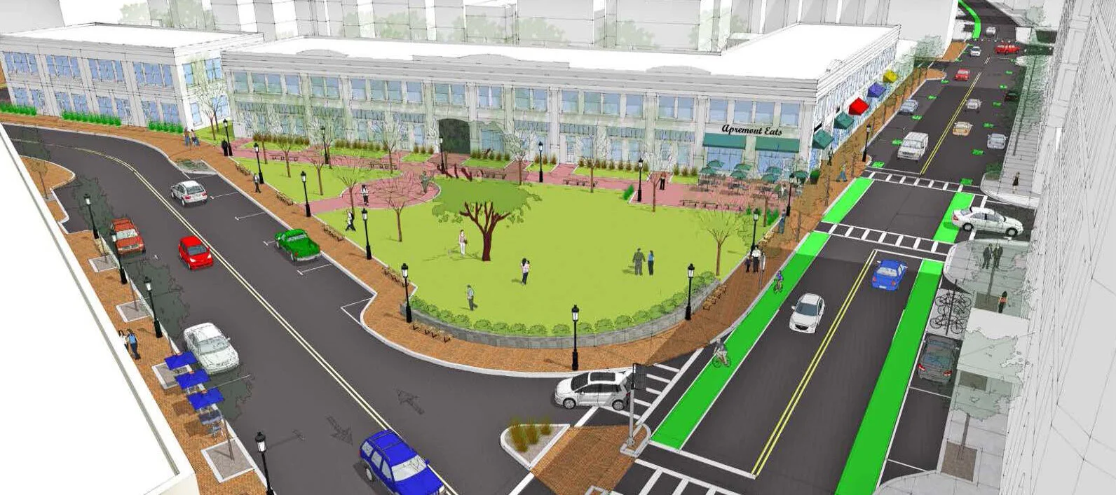
Moving into the more granular aspects of the exercise, specific public realm assets like the Apremont Triangle were re-imagined through an iterative sketch process that addressed issues of open space, traffic flow, building uses and infill opportunities. These sketches were also used as part of a three-dimensional modeling process that allowed people to visualize the proposed changes and imagine what this critical space might be like in the future.

 
Exploring the transformation of public space through the integration of unique landscape qualities and scales

Exploring the transformation of public space through the integration of unique landscape qualities and scales


Exploring more active design strategies that create a variety of types of spaces

Exploring more active design strategies that create a variety of types of spaces


Applying concepts to a 3D model of the space to better understand scale, light, urban edges and vistas

Applying concepts to a 3D model of the space to better understand scale, light, urban edges and vistas


Re-testing the initial concepts in a more fully engineered plan

Re-testing the initial concepts in a more fully engineered plan


Sketching and diagramming never really stop in the course of the design process. As buildings and parks and streets begin to take shape on paper, and the scale of the drawings gets larger and conveys more detail, sketching and diagramming the details serves to constantly clarify intent as well as articulate the finer design details. We often use a metric for judging our own design proposals that poses the following questions:

  • Does the neighborhood or district work when seen in the context of the city?

  • Does the street work when seen in the context of the neighborhood?

  • Does the building work when seen in the context of the street?

If we can keep getting to “yes” as we ask these questions throughout the process, then we know we are in good shape. If we arrive at “no”, then we go back to the drawing board.

Declining Volunteerism and the Case for Connectivity through Mixed-Use Density

By John Rufo in collaboration with Form + Place

We were intrigued by a story in CityLab by Linda Poon last week where the cause and effect of a national decline in the rate of volunteerism was connected to lower rates of home ownership and higher levels of economic stress. Decline in volunteering rates however fell more steeply in rural and suburban areas than in urban areas, suggesting that higher levels of economic distress and social isolation may be more common outside of urban areas. Robert Grimm director of the Do Good Institute says the Social Capital Index measures how “connected a community is” by looking at such data points as “how often residents volunteer in a given year, the number of civic and social organizations per 1,000 people, and how much members trust one another”. In urban areas, where decline in volunteer rates was evident, lower homeownership rates were a common theme. “You can imagine that if you buy a home in a community, you tend to be more anchored to it, and be in it long-term,” says Grimm. “Historically, those kinds of behaviors have led people to be more engaged.”

As architects and planners we asked ourselves what steps should the design and development community be taking to foster community building and engagement? As we strive to solve the housing crisis, how is community connectivity impacted by more rental housing and less home ownership? The inevitability of increased density and a lower rate of home ownership that is the natural result of development in urban areas, does not have to lead to less connectivity.  

Civic spaces transformed for teaching, learning, shopping and connecting

Civic spaces transformed for teaching, learning, shopping and connecting

Advocating for good mixed-use design is one important ingredient in pushing back against disconnected communities. Thoughtful mixed-use planning emphasizes synergy between commercial and residential uses. Successful mixed-use developers will tell you that amenitizing a project with commercial tenants that residents want to be near is a no-brainer. Likewise, retail tenants, restaurants included, want to know how many “roof tops” (read “dwelling units where people sleep”) are in walking or easy commuting distance from the project. While initially the goal of the developer is getting deals done and securing a financial return on the investment, today’s enlightened developers will tell you that the over-arching mechanism making all this possible is integration and connectivity to the larger community.

Well-designed edges fronting on green space and the Time Out Market at 401 Park Drive Boston

Well-designed edges fronting on green space and the Time Out Market at 401 Park Drive Boston

In our experience community connectivity is strengthened when the citizens of a neighborhood can take symbolic ownership of the public realm, even when it is owned and programmed by a private developer. Spaces that invite you in, provide synergy with ground floor businesses and allow for art and engaging programming will ultimately be identified as a key part of the neighborhood. Historically these spaces have played host to speeches, community action, recreation and moments of serendipitous connections. Today they might play the same role or be a place for an outdoor yoga class, a kid’s fair or a farmer’s market. Programming flexibility is key as are well designed edges that people want to occupy.

Davis Square, Somerville + Depot Square, Upper Falls Newton - Small urban spaces programmed for community events, art and leisure

Davis Square, Somerville + Depot Square, Upper Falls Newton - Small urban spaces programmed for community events, art and leisure

While not all projects can satisfy every community’s wish list for favorite tenants and project design, if a development team listens long enough and carefully enough to a community, it can glean the general ethos of a neighborhood and use this as a litmus test for programming and design decisions in an effort to find common ground. At Form + Place our strategy for community building is to creatively engage all voices to find an optimal balance between certainty and flexibility in the development process.

Mixed-use development and careful neighborhood visioning can also yield another critical tool in combating social isolation as evidenced in phenomena like declining volunteer rates.  Projects developed in urban areas with good access to public transportation can cut down on commuting time of residents. “Commuting time is also connected to how people give,” says Linda Poon of City Lab. “The longer it takes people to get to work, the less time they spend on their community and civic obligations.”

It’s interesting to think about this aspect of connectivity in conjunction with the gig economy. “When fewer people engage with each other, that’s where you’re going to have a greater level of social isolation and lower levels of trust in each other” Says Grimm. This may be why co-working and retail co-working have been such popular trends of late. While more of today’s workers may be sole practitioners or connected to very small organizations with little or no workspace footprint, people still want to be around other people. Retail co-working – the use of restaurant spaces that are inactive during the day as co-working space - is a fascinating answer to the isolation problem. A restaurant space by its very nature creates an ambiance of social interaction. Allowing that space to be utilized as a workplace in off hours is a kind of sustainable response to the need for connection and neighborhood resource utilization.

Spacious – The Milling Room – Upper West Side New York – Open daily 8:30 to 5:00

Spacious – The Milling Room – Upper West Side New York – Open daily 8:30 to 5:00

Each city, each town, each neighborhood is different and the attributes that define their character are varied in nature and ever changing. With so much in flux it’s a wonder we can ever feel that a particular project got it right or that an effort to move the needle will bear fruit. But we think that the need for flexibility can be one of the great catalyzing qualities of a development project. Knowing that some tenants will turn over, that economies will change, that fads and styles are ever evolving, and that community consensus will shift, necessitates and inspires us to begin with dialogue and pledge our selves to a continuing conversation.